Bonne’s Carte de l’Isle of Jamaica – 1780
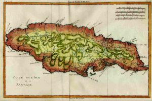
The Island of Jamaica is a wonderful and decorative engraved map of the Caribbean Island of Jamaica. Published in cir. 1780 as part of the Atlas de toutes les parties connues du globe terrestre by France’s Royal Hydrographer, Rigobert Bonne.
Depicting interesting topographical details, with many place names, and identifying the island’s parishes.
A very clean and clear image measuring approximately 8″ high by 12 1/4″ long. Issued with one vertical center fold.
